JapanKnowledge
Downloadable images of detailed and accurate maps of Japan at national, regional, and prefectural levels, available for trial use.
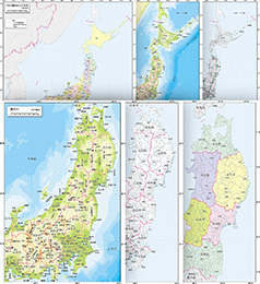
This is a map image collection from Heibonsha Cartographic, who specialize in the editing and production of educational maps, including those found in various textbooks, such as Tokyo Shoseki’s social studies textbooks, and Heibonsha’s own Japan Atlas series.
National, regional, and prefectural maps of Japan are available in six modes – blank outline; blank outline (no place names); natural features; administrative districts; transportation, and administration/gradation. These will prove effective for educational use.
Downloadable JPEG files and PDF files that can be copied and printed have been prepared for the JapanKnowledge School version. We hope you will make use of these for maps to be used in combination with learning activities.
* Maps for certain entries may be unavailable.
Contents information
| Original books | ― |
|---|---|
| Publisher | Heibonsha Cartographic Publishing Co., Ltd. |
| Publication date | ― |
| Number of volumes | ― |
| Book price | ― |
| Release date | April 1, 2021 |
| Number of entries | 77 entries, 450 types |
| Number of characters | ― |
| About search | ― |
| Frequency of update | ― |
| Available services |
|
(as of August 2022)